ArchDaily · Architectuur
UN General Assembly Promotes More Accurate World Map Projections
The UN General Assembly has voted to encourage the use of world map projections that more accurately represent the relative size of continents. The resolution, passed with 164 votes in favor, aims to promote equal-area projections when geographic scale is important, without prohibiting the widely used Mercator projection.
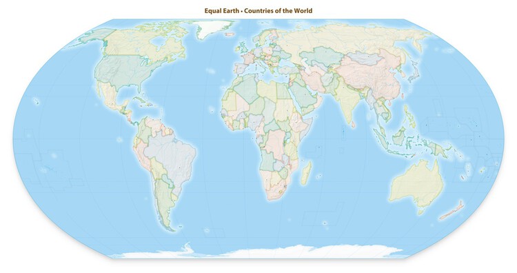
The resolution, sponsored by Togo, was presented at the UN headquarters in New York on September 4. It encourages governments, educational institutions, international organizations, and technology companies to adopt equal-area projections for relevant geographic scales. While not replacing the 16th-century Mercator projection, it advocates for greater use of projections that preserve landmass areas and educates on the limitations of 2D map representations. The 2018 Equal Earth projection is cited as an example of a more accurate continental scale representation.
During the 80th UN General Assembly session, Togo's Foreign Minister Robert Dussey introduced the resolution, highlighting how cartographic representations influence understanding of geographic relationships. The United States was the sole country to vote against it, while Estonia, Georgia, Lithuania, Moldova, Serbia, and Ukraine abstained.
The Mercator projection, developed in 1569 for maritime navigation, preserves angles and compass directions but distorts landmass areas, making regions farther from the Equator appear larger. For instance, Africa, which is about 14 times larger than Greenland, can appear similar in size on a Mercator map.
Despite its navigational origins, the Mercator projection remains common in educational materials, media, and digital mapping, sparking debate about its influence on perceptions of geographic scale and regional positioning.
The Equal Earth projection, created in 2018 by Bojan Šavrič, Tom Patterson, and Bernhard Jenny, is an equal-area projection that accurately preserves the proportional area of landmasses, facilitating better comparisons of continental and country sizes. However, it introduces distortions in shape, distance, and direction, making it more suitable for visualization than navigation.
France has announced its intention to move away from the Mercator projection in its cartographic materials, opting for systems like the Eckert IV projection based on their intended purpose. Concerns were raised by Ukraine and the European Union regarding the depiction of disputed territories on some alternative maps, though the resolution itself does not affect sovereignty or borders.
The UN vote does not establish a single global map standard but acknowledges the limitations of existing projections and promotes the use of different systems according to their purpose. The choice of projection is crucial for communicating geographic information, as no flat map can perfectly preserve area, shape, distance, and direction simultaneously.
AI-samenvatting op basis van de bron.
ArchDaily